The March 10, 1922 shock is the earliest Parkfield earthquake for which seismograms exist. Surface waves from the 1922 and 1934 shocks recorded on the Bosch-Omori seismographs at Berkeley, California, located 240 kilometers northwest of Parkfield, are very similar. Although a comparison of the Berkeley recordings implies that the 1922 epicenter was located 6 kilometers northwest of the 1934 epicenter, uncertainties in the arrival times of waves at Berkeley are such that we can only constrain the 1922 epicenter to the 18-km-long section of fault immediately northwest of the 1934 epicenter. The data permit a common epicenter for the 1922 and 1934 shocks. An oil pipeline (the Producers Transportation Line) which crosses the San Andreas fault near Cholame was broken in 1922 in three places (G. B. Moody, Chevron U. S. A. correspondence, dated July 11, 1934). One of the breaks in 1922 was at the fault trace, close to a 1934 break in a nearby oil pipeline.
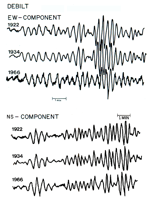
The 6 and 1/2 magnitude originally assigned to the 1922 main shock was based on 20-second-period surface-wave measurements. The comparable measurements in 1966 yield a surface-wave magnitude of 6. More relevant is the comparison of 1922 surface waves recorded worldwide with those for the 1934 and 1966 shocks. The most reliable and convincing data, that recorded at De Bilt, the Netherlands, imply that the seismic moment and surface-wave magnitudes for the 1922 and 1934 shocks are identical to within a precision of about 10 percent. No 1-second-period data exist for the 1922 shock so that no Richter magnitude (ML) estimate is possible.