The San Andreas fault defines an approximately 1300 km (800 mi) portion of the boundary between the Pacific and North American plates (see tectonic map). Along its length, the fault undergoes horizontal strike-slip motion that accommodates most of the relative motion between the plates. To the north, a complex of transform faults and spreading centers accommodates the motion of the Gorda and Juan de Fuca plates. To the south, a similar complex of spreading centers and transform faults accommodate the displacement in the Gulf of California.
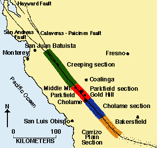
The Town of Parkfield is situated on a relatively straight section of the San Andreas fault in central California, where fault movement occurs as right lateral slip both in earthquakes and as aseismic slip, or "creep". South of Parkfield, large earthquakes (including the M 7.9 Fort Tejon earthquake of 1857) have occurred. From both geodetic and seismic data, currently, the southern section appears to be locked producing no movement or small to moderate sized earthquakes. Similarly, the section of the fault north of San Juan Bautista also has produced large earthquakes, including the M 7.9 San Francisco earthquake in 1906 and the M 6.9 Loma Prieta earthquake in 1989. Most of the northern section of the fault is also currently locked, with no detectable movement and few earthquakes since 1906. Between these locked sections, the San Andreas fault creeps (slips aseismically). From San Juan Bautista to Parkfield, the creeping section produces numerous small (mostly M=5 and smaller) earthquakes but no large ones. The stretch of the fault between Parkfield and Gold Hill defines a transition zone between the creeping and locked behavior of the fault.
The seismicity at Parkfield is noteworthy for several reasons. First, since 1857, six similar, M~6 earthquakes have occurred on the San Andreas fault near Parkfield with apparent regularity—one approximately every 22 years. Secondly, waveforms recorded on regional seismographs are strikingly similar for the 1922, 1934 and 1966 earthquakes, suggesting that these earthquakes involved repeated rupture of the same area on the fault. These observations suggest that there may be some predictability in the occurrence of earthquakes, at least at Parkfield. In addition, much is being learned about the physics of earthquakes from advances at Parkfield, including the discovery of repeating microearthquakes (see Ellsworth, 1995) and earthquake "streaks" (see Waldhauser et al 1999, and Rubin, 1999).