This web page will serve as a single repository and portal for information pertaining to a series of seismological field studies conducted surrounding the San Andreas Fault Observatory at Depth (SAFOD) site in October and November 2003.
Relevant Shots and Data Sets
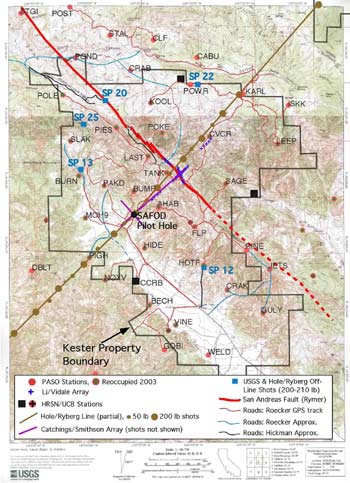
A list of the sources and array/network data available from SAFOD site characterization studies undertaken at Parkfield from Oct. - Nov. 2003, is given below. Individuals requesting data and/or travel time picks from these arrays should directly contact the PIs listed.
Sources:
- Hole/Ryberg in-line shots (63 @ 20 - 400 lbs, mostly 200 lb)
- USGS and Hole/Ryberg off-line shots (5 @ 200 - 210 lbs)
- Catchings et al. auger hole shots (mostly 5 lbs)
- Catchings et al. shot guns
Temporary Arrays:
- Thurber/Roecker array (PASO; contact Cliff Thurber)
- Hole/Ryberg line (contact John Hole)
- Li/Vidale array (contact Yong-gang Li)
- Catchings/Smithson (contact Rufus Catchings)
- Pilot Hole array (contact Peter Malin)
- Ryberg off-line array (contact Trond Ryberg)
Permanent Networks (NCSN and HRSN data available from N. Calif. Data Center):
- Northern California Seismic Network (USGS)
- High Resolution Seismic Network (U.C. Berkeley)
- UPSAR array (USGS, contact Joe Fletcher)
Downloadable data
Download shot locations and origin times, receiver locations, local earthquake catalog, coordinates of San Andreas Fault trace, and general coordinate system information.
- Shot coordinates and origin times: Hole/Ryberg shots and USGS off-line shots (John Hole)
- Shot coordinates and origin times: Catchings et al. shots (Rufus Catchings)
- Receiver coordinates: Thurber/Roecker array (PASO) (Steve Roecker)
- Receiver coordinates: Hole/Ryberg line (John Hole)
- Receiver coordinates: Li/Vidale array (Yong-gang Li)
- Receiver coordinates and shot coords./times: Catchings et al. survey (Rufus Catchings)
- Receiver coordinates: SAFOD pilot hole (sub-surface) (Volker Oye)
- Local earthquake locations and origin times from HRSN, cross-checked with the NCSN catalog, from Oct. 15 - Nov. 30, 2003 (Bob Nadeau)
- Coordinates for local surface trace of the San Andreas Fault (Mike Rymer)
- Coordinate system information and transformations (Steve Roecker)
Notes:
- Tables to be downloaded via this site are in comma-delimited format.
- The name of each person responsible for providing the information indicated above is in parentheses. If your name is listed here, please send the information you are responsible for to the webmaster, Scott Haefner for posting, with cc. to Steve Hickman (hickman@usgs.gov).
- Coordinate Systems: Members of the SAFOD science team have agreed that final data products (e.g., earthquake locations and velocity models) will be portrayed using the UTM projection, North American Datum 1927 (NAD27; the same one used in USSG topographic maps). The web site linked to above was created by Steve Roecker describing how to make the transformation from the various reference frames now in use (e.g., the WGS-84 frame used by most GPS receivers) to UTM/NAD27.
- Elevation Standards: All elevations reported through this web site are in meters above mean sea level, obtained using GPS receivers (with the appropriate corrections) and/or USGS topographic maps and digital elevation models. Detailed instructions on determining accurate station and shot elevations for the Oct/Nov 2003 Parkfield site characterization studies.