Description
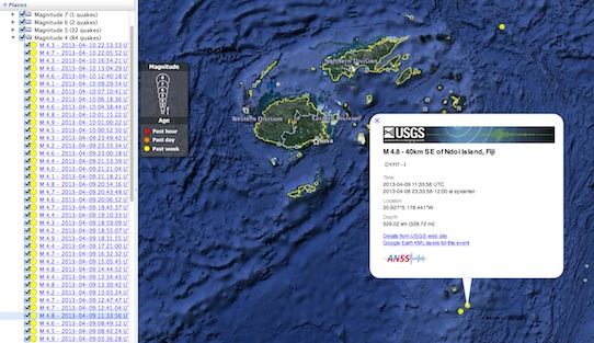
KML is Google's Keyhole Markup Language. The KML feeds offer a variety of options, you can view earthquakes colored by age or depth, and an animated feed allows you to animate the series of earthquakes.
This feed adheres to the USGS Earthquakes Feed Life Cycle Policy.
Usage
You will need to download and install Google Earth to view KML files.
- Automatic Feeds
- These feeds will automatically update every 5 or 15 minutes when downloaded and installed into Google Earth.
- Feeds
- Download a normal KML feed to view earthquake data in Google Earth. You will have to re-download the KML file to access updated earthquake information.
Earthquake Animations
To view earthquake animations in Google Earth follow the directions below:
- Download an animated USGS Earthquakes KML Feed.
- Open the KML using Google Earth.
- Select the earthquake feed, in the left navigation.
-
Use the time slider, in the upper left hand
corner of the map, to animate the series of earthquakes. You may also
click through the animation one frame at a time.
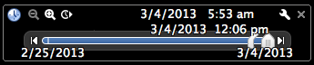
For more information on how to use the time slider, click here.
Output
Screenshot of “Past 7 Days, M1+ Earthquakes, Colored by Age” KML in Google Earth.