M 7.9 - 140 km E of Kokopo, Papua New Guinea
- 2016-12-17 10:51:10 (UTC)
- 4.505°S 153.522°E
- 94.5 km depth
Finite Fault
- The data below are the most preferred data available
- The data below have been reviewed by a scientist
Scientific Analysis
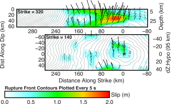
This is an update of an earlier, single-plane model. That prior model suggested shallow interface slip had been triggered by deeper intraplate faulting (where the event initiated). Here we model a two-plane solution, representing intraplate faulting at depth and shallow interface slip. We have tested a suite of models and favor this solution over other, similar, two-plane options, and more complex three-plane models that better represent the rotation in strike in the shallow subduction zone.
Data Process and Inversion
We analyzed 35 teleseismic broadband P waveforms, 4 broadband SH waveforms, and 0 long period surface waves selected based on data quality and azimuthal distribution. Waveforms are first converted to displacement by removing the instrument response and are then used to constrain the slip history using a finite fault inverse algorithm (Ji et al., 2002). We begin modeling using a hypocenter matching or adjusted slightly from the initial NEIC solution ( location = 4.5°S, 153.4°E; depth = 95.0 km ), and a fault plane defined using either the rapid W-Phase moment tensor (for near-real time solutions), or the gCMT moment tensor (for historic solutions).
Result
This result is based on the moment tensor nodal plane ( strike = 140.0°; dip = 48.0° ). The seismic moment release based upon this plane is 8.8e+20 N-m (Mw = 7.9) using a 1D crustal model interpolated from CRUST2.0 (Bassin et al., 2000).
This solution uses 2 plane segments (see Table below) designed to match a priori knowledge of the fault (e.g. 3D slab geometry).
| Segment | Strike | Dip |
|---|---|---|
| 1 | 140.0° | 48.0° |
| 2 | 320.0° | 37.0° |
Cross-section of Slip Distribution
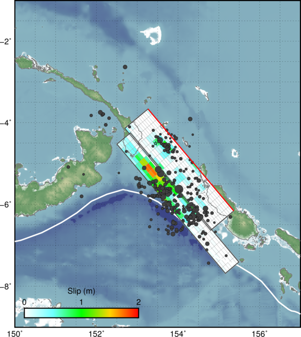
Surface Projection
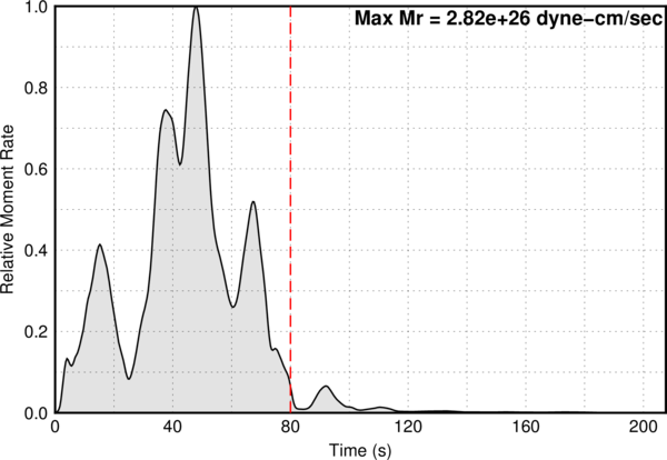
Moment Rate Function