The USGS maintains a variety of fault and volcano monitoring instruments around the western United States, including Hawaii. The data from all instruments are transmitted in real time to the USGS in Menlo Park using satellite, radio and telephone telemetry.
Creepmeters
A creepmeter measures fault slip by recording the displacement between 2 piers or monuments located on opposite sides of the fault, spaced 30 meters apart. Typically, an invar wire (or a graphic rod) is anchored to one pier and is stretched across the fault. Its displacement relative to the second pier is measured electronically and checked periodically with a mechanical measurement. Using the angle of the wire from the strike of the fault, the change in distance between the two piers is directly proportionally to fault slip.
Because the piers are anchored to about 2 meters depth, they are subject to the influence of seasonal (winter) rainfall. Many of the creepmeters show an annual cycle due to the wetting and drying of the near-surface materials within the fault zone. In addition, creep is influenced by large rainfall events and nearby earthquakes.
Strainmeters
Strainmeters for continuous crustal strain monitoring are highly sensitive instruments with precision of less than 1 part per billion (i.e. less than 1 inch in 16,000 miles). They are usually installed in boreholes where surface noise is greatly reduced. These instruments monitor the change in crustal strain near active faults and volcanoes associated with fault slip, earthquakes, and volcanic activity. Currently, numerous instruments have been installed by the USGS along the San Andreas fault, in the Long Valley Caldera, and by other institutions near active faults and volcanoes in the US, Japan, China, Iceland, Italy, and Taiwan.
The Sacks-Evertson dilational borehole strainmeter consists of a stainless-steel cylinder with an annulus filled with silicone oil. Changes in volumetric strain in the ground are detected by small movements of the walls of the borehole and are measured relative to the borehole diameter. This is translated into displacement and voltage by an expansion bellows attached to a linear voltage displacement transducer. The instrument is cemented into the ground at a depth of about 200 meters.The Sacks-Evertson tensor strainmeter is similar in principle but the annulus is divided into three independent segments, 120 degrees apart. Strain is determined in these three directions.
Borehole tensor strain is also measured with a GTSM strainmeter built by GTSM Technologies in Queensland, Australia. These instruments measure strain in three directions, 120 degrees apart (a fourth redundant component is also included at 90 degrees) with a differential capacitance displacement transducer.
Networks of dilational and tensor strainmeters were initially installed in San Juan Bautista, Parkfield, Southern California and Long Valley in the early 1980’s. These networks were later supplemented as increased hazard was identified in Parkfield in the mid-1980’s, Long Valley in 1989, and the San Francisco Bay area in the late 1990’s. A network of six dilational strainmeters and two tensor strainmeters was initially installed along the Hayward fault in the San Francisco Bay area in 1992 with an additional five DTM tensor strainmeters added through the Bay Area in 2001.
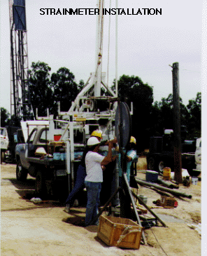
The figure shows a borehole strainmeter being installed to a depth of about 200 meters near the Hayward fault, San Francisco Bay, California. A commercial drill rig is used to drill and case 6" to 8" diameter holes and to core the bottom of these holes until a section of about 10 feet of unfractured rock is obtained. The strainmeter is then installed into a bath of expansive grout within the cored section of the hole. After the grout has set, the instrument detects deformation of the rock. This deformation is converted to ground strain through calibrations obtained from comparing the measured earth tide with the predicted tides in the solid earth corrected for ocean tide loading.
Tiltmeters
Tiltmeters are highly sensitive instruments used to measure ground tilt (rotation) near faults and volcanoes caused by fault slip and volcanic uplift. The precision to which tilt can be measured is less than 1 part per billion (i.e. less than 1 inch in 16,000 miles). For crustal monitoring applications, these instruments are mostly installed in boreholes to avoid spurious ground tilts produced by differential thermal expansion in near-surface materials, rainfall and pumping effects.
Tilt detections systems vary depending on the particular instrument design types used. These design types include simple pendulums (boreholes), liquid level systems (vaults or observatories) or the position of a bubble under concave quartz (similar to a carpenters level). Differential capacitance transducers (DCT’s) are usually used to detect the position of pendulums hanging between two capacitor plates within a tube in a borehole. Linear voltage differential transformers (LVDT’s) and DCT’s are used to determine apparent height changes between the two ends of a liquid level tiltmeter such as the 10 meter mercury-liquid level tiltmeters installed at the Presidio in San Francisco and at Berkeley in the 1960’s and more recently, the 500 meter long baseline tiltmeters installed in Long Valley and the Pacific Northwest by R. Bilham of the University of Colorado. A resistance bridge that locates the position of a bubble under a concave quartz lens is used for both shallow and deep borehole tiltmeters. This type of detection system was used in five of the seven tiltmeters installed in the San Francisco Bay area from 1992 to 2001.
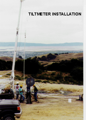
The figure shows borehole strainmeters and tiltmeters being installed at a depth of about 200 meters near the Hayward fault, San Francisco Bay, California. A water-well drill rig is usually used to drill and case these boreholes and to core the bottom of these holes. Tiltmeters are usually cemented well within the casing to avoid tilting from movement on localized cracks and fractures. Tiltmeters are calibrated using theoretical earth tides in the solid earth with ocean loading corrections.