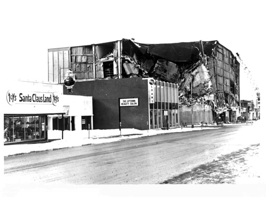
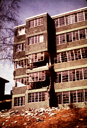
Five-story J.C. Penney Building, 5th Avenue and Downing Street, Anchorage, Alaska, partly collapsed by the March 28, 1964 earthquake.
Note undamaged buildings nearby.
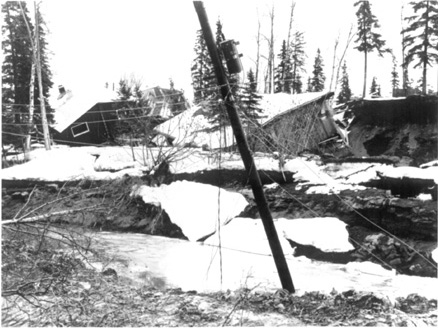
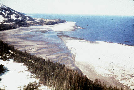
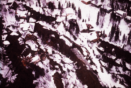
Landslide and slumping effects in the Turnagain Heights area, Anchorage, Alaska, caused by the March 28, 1964, earthquake.
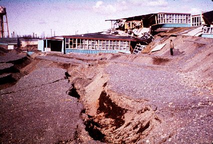
Close-up of Government Hill elementary school, which
was destroyed by the Government Hill landslide.
Anchorage, Alaska.
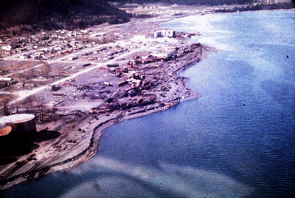
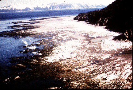
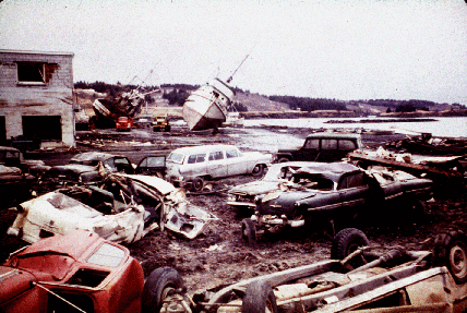
The waterfront at Seward a few months after the earthquake,
looking north. Note the "scalloped" shoreline left by the
underwater landslides that severed tracks in the railroad yard
which dangle over the landslide scarp and the windrow-like
heaps of railroad cars and other debris thrown up by the
tsunami waves. Alaska.
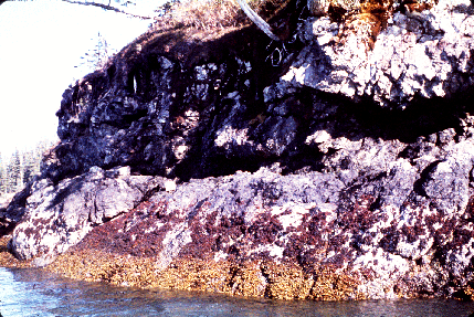
Uplifted sea floor at Cape Cleare, Montague Island,
Prince William Sound, in the area of greatest recorded
tectonic uplift on land (33 feet). The very gently
slopping flat rocky surface with the white coating
which lies between the cliffs and the water is about a
quarter of a mile wide. It is a wave cut surface that
was below sea level before the earthquake. The white
coating consists of the remains of calcareous marine
organisms that were killed by
desiccation when the wave cut
surface was lifted above the high tide during the earthquake.
Uplifted dock on Hinchinbrook Island, Prince William Sound.
Land in this area rose about 8 feet during the earthquake,
and the dock can now be used only at extremely high tides.
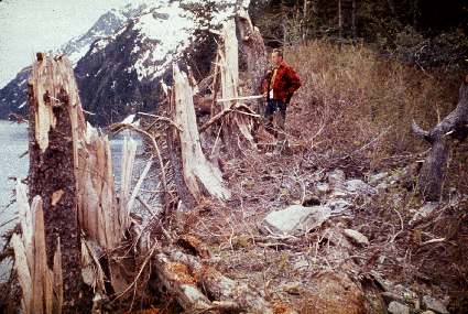
The stumps in the foreground are part of an ancient forest
on Latouche island, Prince William Sound, that was
submerged below sea level and buried in prehistoric times.
Tectonic uplift of 9 feet during the earthquake raised
these stumps above sea level once again, demonstrating
that the area is tectonically restless.
The amount of tectonic uplift on Glacier Island, Prince
William Sound, was shown by the upper limit to which
algae of the intertidal zone are on this sea cliff before
and after the earthquake. The top of the band of green
(still living) algae is near present (post earthquake)
mean high tide. The top of the band of brown (desiccated)
algae marks the approximate position of mean high tide
before the earthquake. The difference in height between
the top of the bands of living and of desiccated algae
(3 feet) is a measure of the amount of tectonic uplift
in this area.
View southwest along the Hanning Bay fault scarp on southwest Montague
Island in Prince William Sound. The Hanning Bay fault was reactivated
during the earthquake. Its trace is marked by 10 to 15 feet high bedrock
scarp which trends obliquely across the field of view from the right
foreground to the left background. The fault trace lies between the
uplifted wave cut surface that is coated white by desiccated calcareous
marine organisms and borders the open ocean and the area of brown sand
and silt in the cove. The ground northwest of the fault (right side of
photo) was displaced upward as much as 16 feet with respect to the ground
southeast of the fault during the earthquake, but both sides of the fault
were uplifted with respect to sea level due to general tectonic uplift
of the region. The fault plane dips steeply NW, or is vertical.
Close-up view of tsunami damage along the
waterfront at Kodiak.
The Hillside apartment building in Anchorage was severely
damaged by the earthquake and has been razed. It was a
split-level, five story building with steel posts and
lintels, concrete floor slabs, and unreinforced concrete
block walls and partitions.
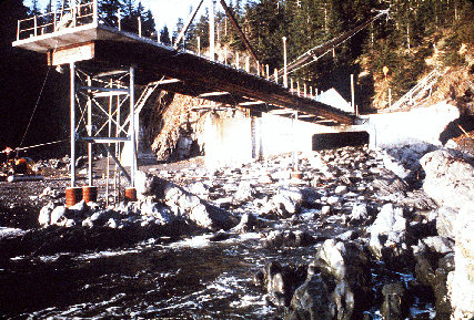
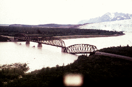
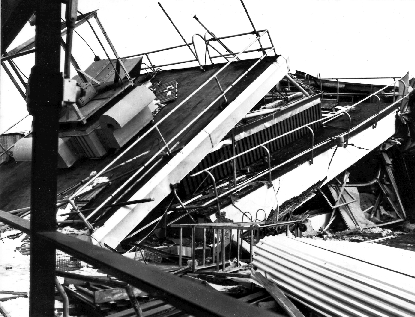
One span of the "Million Dollar" truss-bridge of the former
Copper River and Northwestern Railroad was dropped into the
Copper River by the earthquake, and the other truss spans
were shifted on their piers.
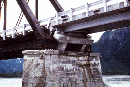
The earthquake shifted the steel trusses of the Copper
River and Northwestern Railroad bridge near Round Island
from 1 to 2 feet. This view shows one of the displaced
trusses, which pounded against an adjacent steel girder
span. The girder span was moved to the right, its
concrete pedestal was rotated, and the girder span almost
fell into the river. Note the shortening indicated by
buckling of the guardrail.
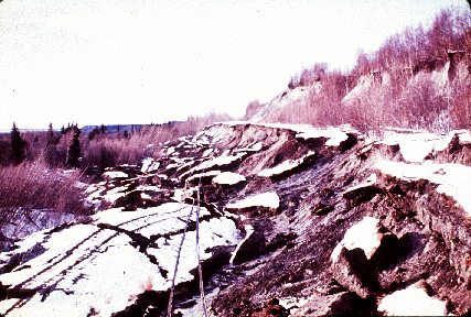
A series of earthquake triggered landslides in glacial
deposits disrupted almost a mile of The Alaska Railroad
main line at Potter Hill, near Anchorage.
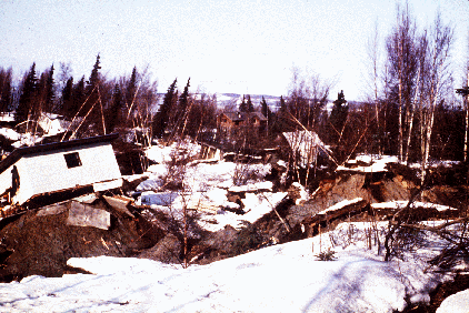
Close-up of damaged homes at Turnagain Heights landslide,
Anchorage.
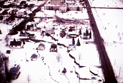
A subsidence trough (or graben) formed at the head of the
"L" Street landslide in Anchorage during the earthquake.
The slide block, which is virtually unbroken ground to the
left of the graben, moved to the left. The subsidence
trough sank 7 to 10 feet in response to 11 feet of
horizontal movement of the slide block. The volume of the
trough is theoretically equal to the volume of the void
created at the head of the slide by movement of the slide
block. A number of houses seen in this photograph were
undercut or tilted by subsidence of the graben. Note also
the collapsed Four Seasons apartment building
and the undamaged three story
reinforced concrete frame building beside it, which are on
the stable block beyond the graben.
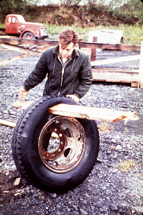
A detail illustrating the violence of the surge waves that
struck Whittier: man holds mounted tire where wave has
driven a piece of wood through the tire.
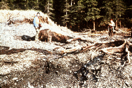
Trees up to 24 inches in diameter and between 88 and 101 feet above
sea level were broken and splintered by the surge wave generated
by an underwater landslide in Port Valdez, Prince William Sound.
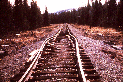
The rails in this approach to a railroad bridge near the
head of Turnagain Arm were torn from their ties and
buckled laterally by channelward movement of the river
banks during the earthquake. The bridge was also
compressed and developed a hump from vertical buckling.
The rails were buckled by lateral movement of the embankment fill
toward an underlying culvert, which had collapsed.
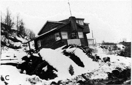
House displaced by compressional ridge formed at toe of L Street landslide Anchorage district. Cook Inlet region, Alaska. 1964.
Control tower at Anchorage International Airport, collapsed by earthquake
shaking. Anchorage district, Cook Inlet region, Alaska.
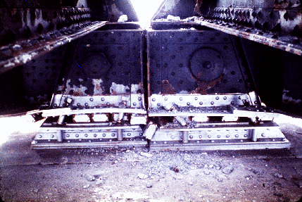
Close-up view of the damage created at the piers of the
"Million Dollar" truss bridge by movement of the truss
spans during the earthquake. Note the bent base plates,
the sheared 2-inch diameter bolts and the overturned rocker bars.
The Turnagain Heights landslide in Anchorage, occurred along a
steep bluff fronting Knik Arm of Cook Inlet. Its length, which
is parallel to the bluff, was about 1.5 miles; its width was
about .25 to .50 miles. This landslide reduced to rubble many
of the finer homes of the city. Failure here, and in the
"L" Street, Fourth Avenue, and Government Hill landslides in
Anchorage occurred on horizontal or near horizontal slip surfaces
in the Bootlegger Cove Clay, a marine silt of Pleistocene age.
Alaska.
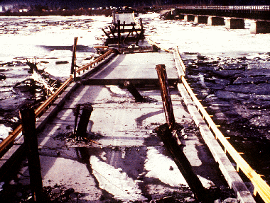
This reinforced concrete deck of highway bridge across Twenty
Mile River near Turnagain Arm of Cook Inlet fell into the
river during the earthquake; the adjacent steel railroad
bridge survived with only minor damage. Both bridges were
founded on thick deposits of soft alluvium and tidal flat
mud, and were subjected to severe seismic vibration.
During the earthquake some of the concrete deck sections
hit the underlying wood pilling with sufficient force to
drive the bare ends of the wood piles through the concrete
deck.
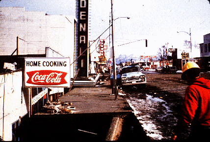
The marquee of the Denali Theater, which was in the graben
of the Fourth Avenue landslide in Anchorage, subsided
until it came to rest on the sidewalk in front of the
theater, which was on ground that was not involved in the
landslide.
This truck at Lowell Point, 2 miles from Seward, was bent
around a tree by the surge waves generated by the
underwater landslides along the Seward waterfront. The
truck was about 32 feet above water level at the time of
the earthquake.
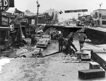
Collapse of Fourth Avenue near C Street, Anchorage, due to
earthquake caused landslide. Before the earthquake, the
sidewalk at left, which is in the graben, was at street level
on the right. The graben subsides 11 feet in response to 14
feet of horizontal movement. Anchorage district, Cook Inlet region,
Alaska. 1964.
Photos from the Earth Science Photographs from
the U.S. Geological Survey Library,
by Joseph K. McGregor and Carl Abston,
U.S. Geological Survey
Digital Data Series DDS-21, 1995.