
M 6.0 - 4 km NNE of Massa Finalese, Italy
- 2012-05-20 02:03:52 (UTC)
- 44.890°N 11.230°E
- 6.3 km depth
PAGER
- The data below are the most preferred data available
- The data below have NOT been reviewed by a scientist.
Estimated Fatalities

Estimated Economic Losses

Estimated Population Exposure to Earthquake Shaking
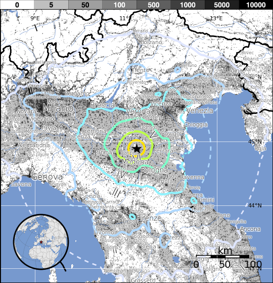
| MMI | Shaking | Population |
|---|---|---|
| Not Felt | 3,021 k* | |
| Weak | 20,487 k* | |
| Light | 6,551 k | |
| Moderate | 1,311 k | |
| Strong | 312 k | |
| Very Strong | 99 k | |
| Severe | 0 k | |
| Violent | 0 k | |
| Extreme | 0 k |
*Estimated exposure only includes population within map area (k = x1,000)
Modified Mercalli Intensity (MMI) scale
Structure Information Summary
Overall, the population in this region resides in structures that are a mix of vulnerable and earthquake resistant construction. The predominant vulnerable building types are unreinforced brick with mud and mid-rise nonductile concrete frame with infill construction.
Secondary Effects
Recent earthquakes in this area have caused secondary hazards such as landslides that might have contributed to losses.
| MMI | City | Population |
|---|---|---|
| Finale Emilia | 15 k | |
| San Felice sul Panaro | 10 k | |
| Magnacavallo | 2 k | |
| Poggio Rusco | 6 k | |
| Camposanto | 3 k | |
| Sermide | 6 k | |
| Mirandola | 22 k | |
| Medolla | 6 k | |
| Felonica | 2 k | |
| San Giovanni del Dosso | 1 k |
From GeoNames Database of Cities with 1,000 or more residents (k = x1,000)