M 7.2 - 56 km NW of Te Anau, New Zealand
- 2003-08-21 12:12:49 (UTC)
- 45.104°S 167.144°E
- 28.0 km depth
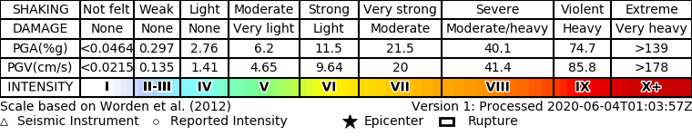
ShakeMap
- The data below are the most preferred data available
- The data below have NOT been reviewed by a scientist.
Official websites use .gov
A .gov website belongs to an official government organization in the United States.
Secure .gov websites use HTTPS
A lock ( ) or https:// means you’ve safely connected to the .gov website. Share sensitive information only on official, secure websites.