

M 6.1 - 210 km WNW of Nikolski, Alaska
- 2014-02-26 21:13:40 (UTC)
- 53.605°N 171.821°W
- 265.0 km depth
Interactive Map Regional Information Felt Report - Tell Us! 000000Responses Contribute to citizen science. Please tell us about your experience.
- ShakeMap
IVmmi 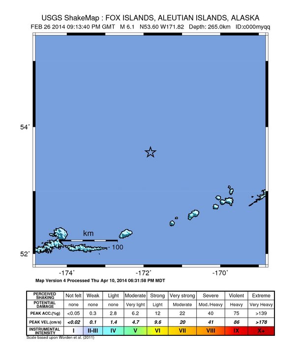
Estimated Intensity Map - PAGER
GREEN 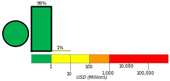
Estimated Economic Losses 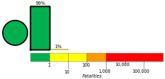
Estimated Fatalities Origin - Review Status
- REVIEWED
- Magnitude
- 6.1 mww
- Depth
- 265.0 km
- Time
- 2014-02-26 21:13:40 UTC
Moment Tensor Fault Plane Solution Tsunami 
U.S. Tsunami Warning System To view any current tsunami advisories for this and other events please visit https://www.tsunami.gov.
View Nearby Seismicity - Time Range

± Three Weeks - Search Radius

250.0 km - Magnitude Range

≥ 3.0
Contributors US

USGS National Earthquake Information Center, PDE