
M 5.4 - 151 km NNW of Las Khorey, Somalia
- 2023-12-05 20:19:53 (UTC)
- 12.341°N 47.489°E
- 10.0 km depth
PAGER
- The data below are the most preferred data available
- The data below have NOT been reviewed by a scientist.
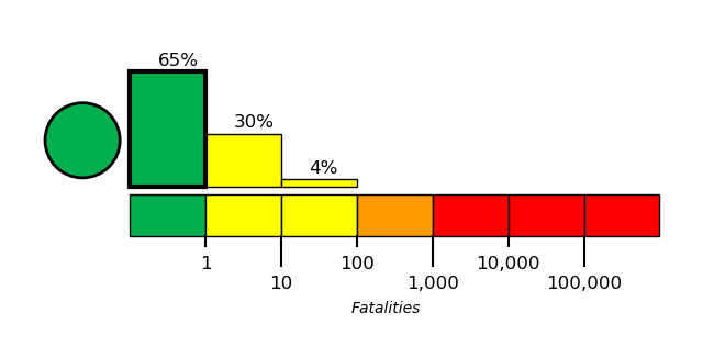
Estimated Fatalities
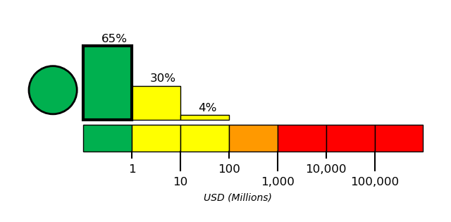
Estimated Economic Losses
Estimated Population Exposure to Earthquake Shaking
| MMI | Shaking | Population |
|---|---|---|
| Not Felt | 0 k* | |
| Weak | 926 k* | |
| Light | 0 k | |
| Moderate | 0 k | |
| Strong | 0 k | |
| Very Strong | 0 k | |
| Severe | 0 k | |
| Violent | 0 k | |
| Extreme | 0 k |
*Estimated exposure only includes population within map area (k = x1,000)
Modified Mercalli Intensity (MMI) scale
Structure Information Summary
Overall, the population in this region resides in structures that are extremely vulnerable to earthquake shaking, though some resistant structures exist. The predominant vulnerable building type is low-rise nonductile concrete frame with infill construction.
| MMI | City | Population |
|---|---|---|
| Ahwar | 0 k | |
| Las Khorey | 7 k | |
| Rudum | 0 k | |
| Ceerigaabo | 34 k | |
| Jawf al Maqbabah | 14 k | |
| Mudiyah | 0 k | |
| Al Mahfid | 0 k | |
| Bosaso | 74 k | |
| Al Wuday` | 0 k | |
| Lawdar | 0 k |
From GeoNames Database of Cities with 1,000 or more residents (k = x1,000)