
M 5.9 - Xizang-Qinghai border region
- 2016-10-17 07:14:50 (UTC)
- 32.896°N 94.877°E
- 35.0 km depth
PAGER
- The data below are the most preferred data available
- The data below have NOT been reviewed by a scientist.
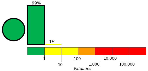
Estimated Fatalities
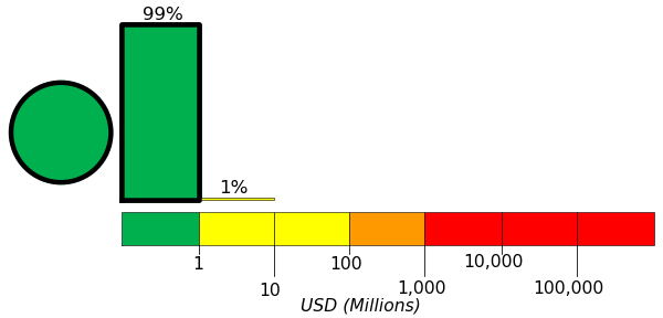
Estimated Economic Losses
Estimated Population Exposure to Earthquake Shaking

| MMI | Shaking | Population |
|---|---|---|
| Not Felt | 0 k* | |
| Weak | 991 k* | |
| Light | 84 k | |
| Moderate | 0 k | |
| Strong | 0 k | |
| Very Strong | 0 k | |
| Severe | 0 k | |
| Violent | 0 k | |
| Extreme | 0 k |
*Estimated exposure only includes population within map area (k = x1,000)
Modified Mercalli Intensity (MMI) scale
Structure Information Summary
Overall, the population in this region resides in structures that are highly vulnerable to earthquake shaking, though some resistant structures exist.
| MMI | City | Population |
|---|---|---|
| Aduo | 0 k | |
| Zaqing | 0 k | |
| Jieduo | 0 k | |
| Sulu | 0 k | |
| Namsai | 0 k | |
| Zhexiao | 0 k | |
| Domba | 0 k | |
| Duocai | 0 k | |
| Gyairong | 0 k | |
| Gyobrag | 0 k |
From GeoNames Database of Cities with 1,000 or more residents (k = x1,000)