M 6.6 - 142 km WNW of Corral del Risco (Punta de Mita), Mexico
- 1948-12-04 00:22:48 (UTC)
- 21.182°N 106.818°W
- 15.0 km depth
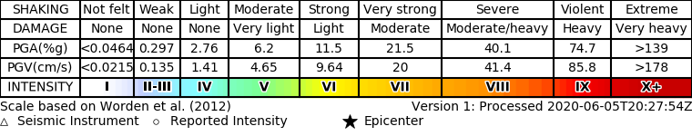
ShakeMap
- The data below are the most preferred data available
- The data below have NOT been reviewed by a scientist.
Official websites use .gov
A .gov website belongs to an official government organization in the United States.
Secure .gov websites use HTTPS
A lock ( ) or https:// means you’ve safely connected to the .gov website. Share sensitive information only on official, secure websites.