M 6.4 - 140 km SW of Kokopo, Papua New Guinea
- 1953-01-07 14:08:33 (UTC)
- 5.368°S 151.523°E
- 55.2 km depth
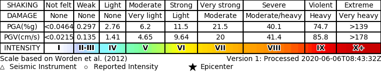
ShakeMap
- The data below are the most preferred data available
- The data below have NOT been reviewed by a scientist.
Official websites use .gov
A .gov website belongs to an official government organization in the United States.
Secure .gov websites use HTTPS
A lock ( ) or https:// means you’ve safely connected to the .gov website. Share sensitive information only on official, secure websites.