M 6.0 - 9 km SSW of Uvira, Democratic Republic of the Congo
- 1954-07-03 00:32:59 (UTC)
- 3.471°S 29.097°E
- 15.0 km depth
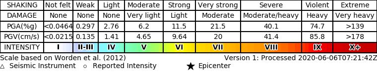
ShakeMap
- The data below are the most preferred data available
- The data below have NOT been reviewed by a scientist.
Official websites use .gov
A .gov website belongs to an official government organization in the United States.
Secure .gov websites use HTTPS
A lock ( ) or https:// means you’ve safely connected to the .gov website. Share sensitive information only on official, secure websites.