M 6.7 - 3 km ESE of Browns Point, Washington
- 1965-04-29 15:28:45 (UTC)
- 47.288°N 122.406°W
- 64.7 km depth
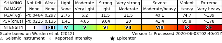
ShakeMap
- The data below are the most preferred data available
- The data below have NOT been reviewed by a scientist.
Official websites use .gov
A .gov website belongs to an official government organization in the United States.
Secure .gov websites use HTTPS
A lock ( ) or https:// means you’ve safely connected to the .gov website. Share sensitive information only on official, secure websites.