M 5.8 - Guerrero-Michoacan border region, Mexico
- 1967-04-13 19:59:53 (UTC)
- 18.309°N 100.125°W
- 85.0 km depth
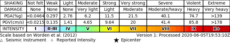
ShakeMap
- The data below are the most preferred data available
- The data below have NOT been reviewed by a scientist.
Official websites use .gov
A .gov website belongs to an official government organization in the United States.
Secure .gov websites use HTTPS
A lock ( ) or https:// means you’ve safely connected to the .gov website. Share sensitive information only on official, secure websites.