M 7.5 - 27 km SSE of San Andrés Playa Encantada (El Podrido), Mexico
- 1909-07-30 10:51:51 (UTC)
- 16.463°N 99.529°W
- 20.0 km depth
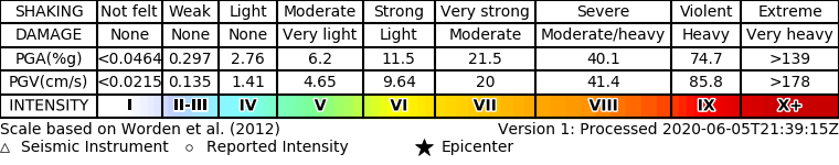
ShakeMap
- The data below are the most preferred data available
- The data below have NOT been reviewed by a scientist.
Official websites use .gov
A .gov website belongs to an official government organization in the United States.
Secure .gov websites use HTTPS
A lock ( ) or https:// means you’ve safely connected to the .gov website. Share sensitive information only on official, secure websites.