M 6.4 - The 1954 San Jacinto Fault, California Earthquake
- 1954-03-19 09:54:27 (UTC)
- 33.299°N 116.081°W
- 6.0 km depth
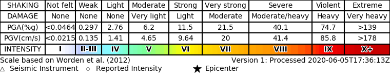
ShakeMap
- The data below are the most preferred data available
- The data below have NOT been reviewed by a scientist.
Official websites use .gov
A .gov website belongs to an official government organization in the United States.
Secure .gov websites use HTTPS
A lock ( ) or https:// means you’ve safely connected to the .gov website. Share sensitive information only on official, secure websites.