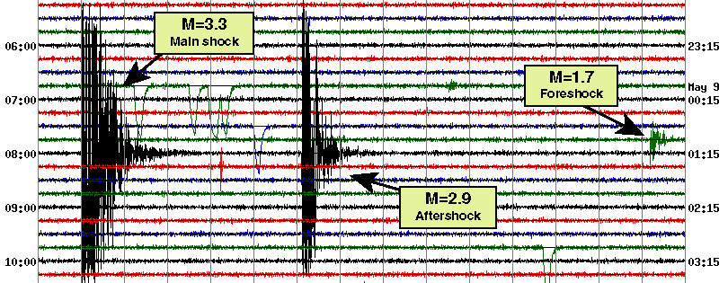
Foreshock - Main shock - Aftershock Sequence
The three earthquakes shown below occurred at virtually the same location (8 km ENE of Watsonville) and within 7 minutes of each other on May 9, 2000, as detailed in the table below.
| Time, PDT | Magnitude | Latitude | Longitude | Depth | Designation |
|---|---|---|---|---|---|
| 00:59:06 | M=1.7 | 36.939 | -121.679 | 8 | Foreshock |
| 01:00:55 | M=3.3 | 36.246 | -120.821 | 8 | Main shock |
| 01:06:02 | M=2.9 | 36.244 | -120.829 | 8 | Aftershock |
The record from station HFP (Fremont Peak; 9 miles SW of Hollister, 18 miles SSE of Gilroy; 36.754, -121.492) is shown below. The closeness in time and location of these earthquakes to each other is no coincidence. Earthquakes "interact", meaning that the stress changes produced by one earthquake can encourage others to occur nearby, thereby producing clusters of events. The most common form of cluster is the main shock and its aftershocks, the main shock being first and having the largest magnitude. When an earthquake (like the M=1.7 event here) triggers a larger earthquake (the M=3.3 event here), the first is called a "foreshock".
Magnitude 1.9 Earthquake
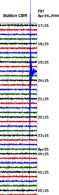
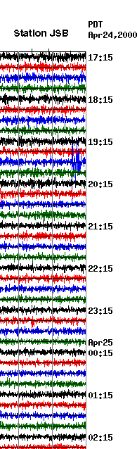
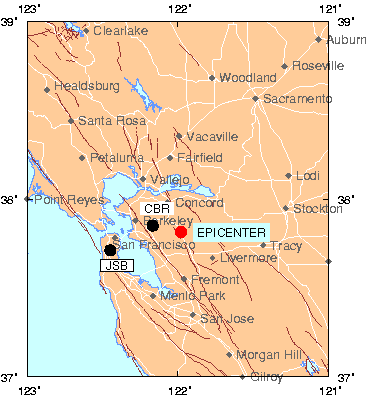
Seismogram recorded by CBR, the station closest to the earthquake (among those in our web page display) in Bollinger Canyon, 6 miles south of Walnut Creek and 10 miles north of Hayward and from station JSB, located across San Francisco Bay on San Bruno Mountain.
Here we see one earthquake recorded on two stations. The earthquake occurred at 19:44 PDT April 24 (02:44 UTC, April 25), 2000, 6 km northeast of Danville, Calif, at a depth of 7 km (red dot on map). The magnitude is 1.9.
Magnitude 3.1 Earthquake
Three earthquakes, the largest having a magnitude of 3.1, occurred within two hours of each other on May 7, 2000, as detailed in the table below.
| Time, PDT | Magnitude | Latitude | Longitude | Depth | Approximate Locaton | Distance to HFP | Distance to BBG |
|---|---|---|---|---|---|---|---|
| 08:05 | M=2.1 | 36.866 | -121.597 | 6.3 km | Near San Juan Bautista | 16 km | 60 km |
| 08:50 | M=2.7 | 36.246 | -120.821 | 6.4 km | Near New Idria | 82 km | 42 km |
| 09:50 | M=3.1 | 36.244 | -120.829 | 6.0 km | Near New Idria | 82 km | 42 km |
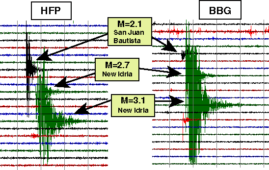
Seismograms from two stations, HFP (Fremont Peak; 9 miles SW of Hollister, 18 miles SSE of Gilroy) and BBG (Big Mountain; 7 miles ENE of Pinnacles, 26 miles N of King City) captured all three events. The New Idria events are closer to BBG than HFP, while the San Juan Bautista event is closer to HFP than to BBG.
These distance relationships can be seen in two ways. First, the New Idria events registered higher amplitudes at BBG than at HFP, while the San Juan Bautista event had higher amplitudes at HFP than at BBG. Secondly, if you look closely you will see that the first waves from the San Juan Bautista event arrive slightly earlier at HFP than at BBG. Conversely, the first waves from the New Idria events arrived at BBG first.
Magnitude 4.0 Earthquake
Epicenter near near Cloverdale, CA on January 10, 2000
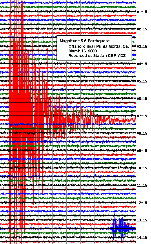
Magnitude 5.6 Earthquake
Epicenter near near Punta Gorda, CA on March 16, 2000
Teleseisms
A teleseism is a record of an earthquake made by a seismograph at a great distance.
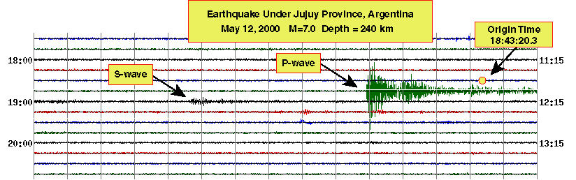
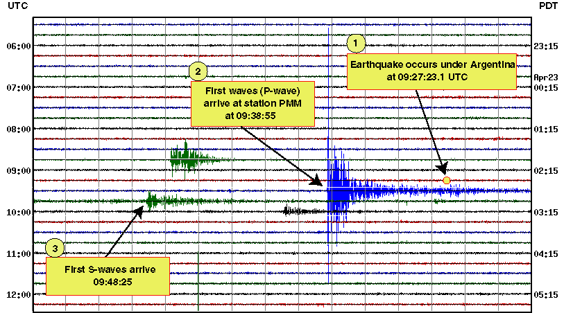
On April 23, 2000, a magnitude 6.9 (Mw) earthquake occurred at 09:27:23.1 (UTC) approximately 600 km below Santiago del Estero Province, Argentina (1). The fastest-traveling seismic waves (P-waves) traveled through the earth's mantle and arrived at station PMM (located near Parkfield, California) about 11 minutes later, at 09:38:55 UTC (2). The slower-traveling S-waves also travelled through the mantle, and reached Parkfield 21 minutes after the earthquake occurred (3). The signal arriving at 08:49 (green trace) is from a M=3.4 earthquake (origin time 08:48:39) in southern California, approximately 200 km ESE of this station. The signal at 10:07 (black trace) is an unidentified later arrival from the Argentina event.
A second earthquake under Argentina, magnitude 7.0 (Mw), occurred May 12, 2000, at 18:43:20.2 (UTC), 240 km below Jujuy Province. The record from this earthquake, again at station PMM, is similar to that from the April 23rd event because the events occurred in roughly the same area and are both relatively deep.
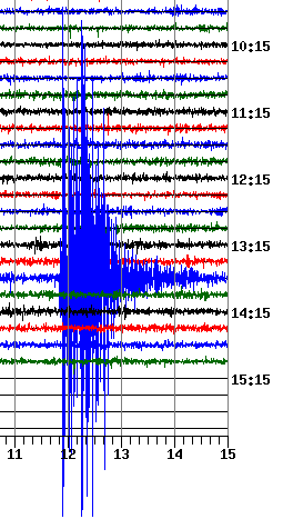
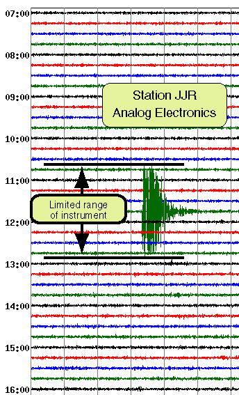
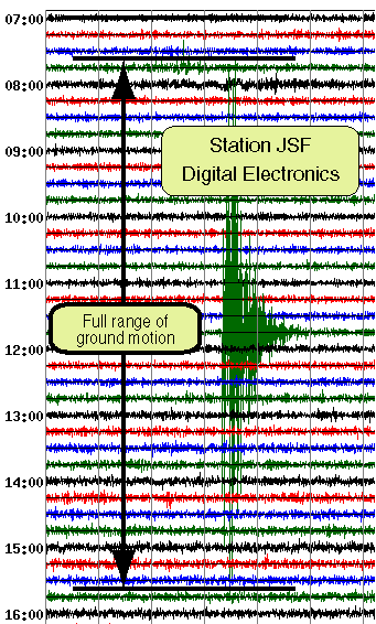
Clipped Records
Clipping occurs when the amount of ground motion exceeds the range that can be recorded by an instrument.
Most of the instruments in the Northern California Seismic Network use analog electronics capable of recording only a limited range of ground motion. Gradually, they are being replaced with more modern, digital electronics with a larger dynamic recording range.
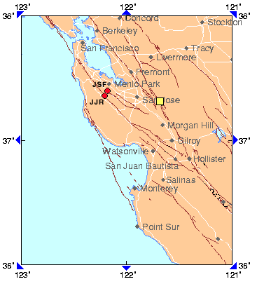
Here we see one earthquake (yellow square) recorded on two stations (red dots), both 45 km away. The earthquake (magnitude = 3.5) occurred at 04:48 PDT June 13 (11:48 UTC, June 13), 2000, 19 km east of San Jose, Calif, at a depth of 8 km on the Calaveras fault. These two stations use identical sensors, but one uses analog electronics, the other digital.
Quarry Blast
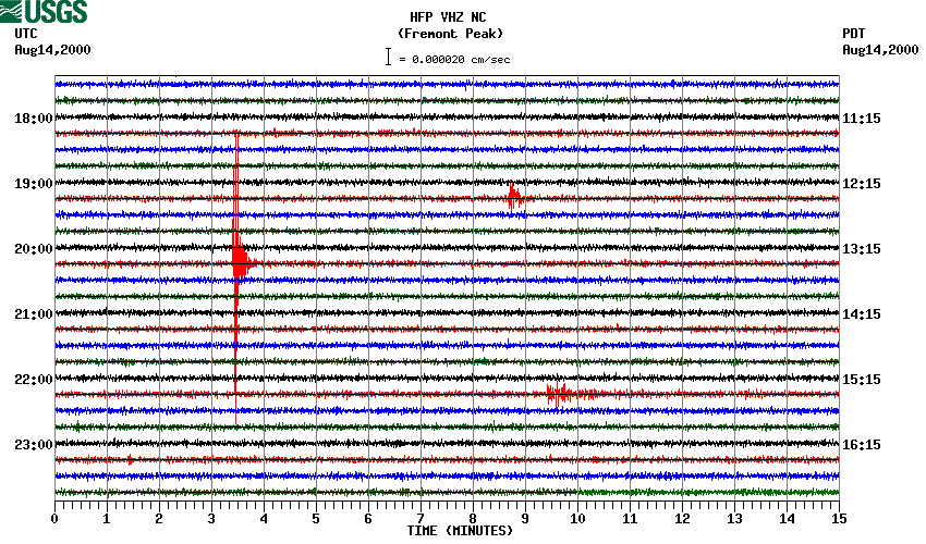
The seismogram below is a portion of the daily record for August 14, 2000 from Fremont Peak station HFP. The prominent signature shortly after 20:18:22 UTC has many of the characteristics of a small nearby earthquake. It has, for instance, an abrupt onset and an exponential decay indicative of an earthquake having a duration magnitude of 1.7. Based upon it's magnitude (<2.0), location (within a km of a known quarry location), and time (mid-day is a common time for quarry blasts), however, this event is probably a quarry blast from a quarry near Natividad, CA.
High Winds
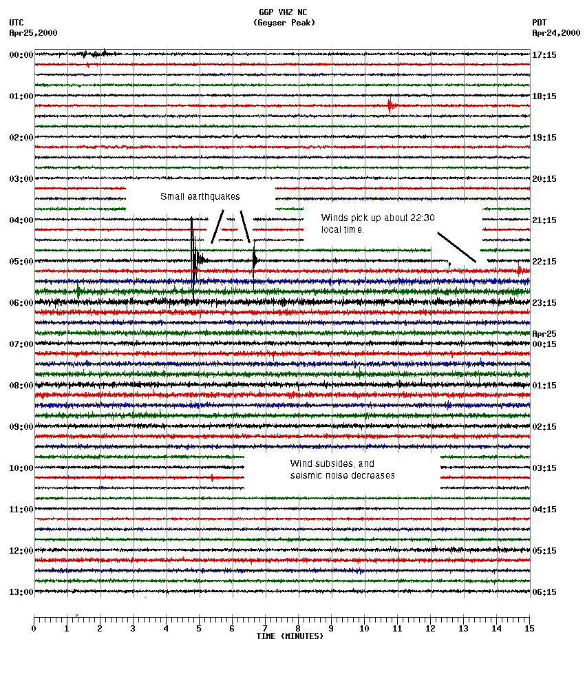
The seismogram below documents a windy night at Geyser Peak station (GGP). From about 22:30 PDT on April 24 to 02:25 on April 25, the wind blew hard in coastal central California as a weather front passed through. Wind can produce low-amplitude seismic waves or "microseisms" in the earth through the action of trees, which transfer wind-generated forces into the ground through their roots. (Ocean waves also generate microseisms by the pounding of the surf.) Here, the wind-generated noise appears as an increase in the amplitude of the smallest background motions detected by this seismometer. Also, two small earthquakes are visible at 22:04 and 22:06, PDT.
Calibration Pulse
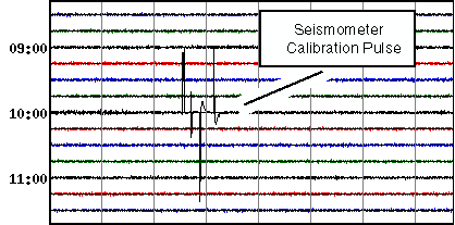
Many of the seismometers in our network are of the magnet-coil-spring type. This type of instrument consists of a permanent magnet and a coil of wire. The coil, which is wound around a rather massive core, is suspended by a spring. When the ground moves, the coil tends to remain in place due to its mass, while the magnet, which is rigidly attached to the seismometer housing, moves relative to the coil. The relative motion produces a current in the coil, and it is this electrical signal that ends up being recorded as a seismogram.
The mechanical response of the magnet, springs and coil, as well as the electronics that amplifies the current, all affect the final signal. If the springs weaken or the electronics drifts, for example, the seismogram will not be accurate. Since these seismometers are located all over northern California, it is not practical to visit each one to check its performance.
Instead, the seismometer is programmed to check itself. Once a day, the electronics in the seismometer sends a controlled current through the coil. The response of the magnet-spring-coil system to this test signal is sent back as a calibration pulse. These pulses can be measured at the central recording site in Menlo Park, California, to assure that each seismometer is functioning properly.