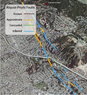
The Alquist-Priolo Earthquake Fault Zoning Act's main purpose is to prevent the construction of buildings used for human occupancy on the surface trace of active faults. Before a new project is permitted, cities and counties require a geologic investigation to demonstrate that proposed buildings will not be constructed on active faults.
Google Earth File
This layer depicts Quaternary faults that are designated by the Alquist-Priolo Fault Zone Act as active. The Alquist Priolo earthquake fault zones, which are regulatory zones around these active faults, are not included in this file. Maps of the Alquist Priolo fault zones may be obtained from the California Geologic Survey.
Alquist-Priolo Faults(6 kB)