At the surface, an offset of 20 feet was observed near Point Reyes. (Lawson report)

This picture, taken near Bolinas in Marin County by G.K. Gilbert, shows a fence that was offset about 8.5 feet along the trace of the fault (from Steinbrugge Collection of the UC Berkeley Earthquake Engineering Research Center)
At depth the slip was probably larger. A recent study by Thatcher, Marshall, and Lisowski found from a re-analysis of geodetic measurements that there was probably 24 feet of slip at depth near Point Reyes and up to 28 feet near Shelter Cove at the north end of the rupture. Over the southern 100 miles of the rupture, slip was much less, averaging 8-12 feet.
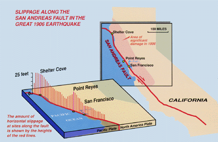
This figure shows the size of offsets inferred at depth at various locations along the fault.
Another plot of this slip distribution at depth, also from Thatcher, Marshall, and Lisowski.