The magnitude 6.8 Hayward earthquake on October 21, 1868 was one of the most damaging earthquakes in California history. Known at the time as the "Great San Francisco earthquake," it violently shook San Francisco and surrounding cities, killing 30. Yet, few San Francisco Bay Area residents know about the earthquake.
Recent geological studies indicate that the average interval between the past five large earthquakes on the Hayward Fault is 140 years, meaning that another large quake can occur at any time. Because the Bay Area’s population has grown by more than 25 times since 1868, the next large quake could potentially cause hundreds of deaths and leave thousands homeless.
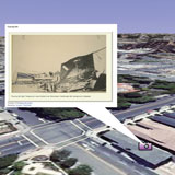
Over time, memories of the 1868 Hayward earthquake have faded. Using this self-guided, virtual tour of the 1868 quake in Google Earth you can learn about the 1868 earthquake, visualize its effects, and better plan for its expected repeat. You can view historic damage photographs side-by-side with modern photos taken from the same vantage point. You can also learn how urbanization has changed the Bay Area landscape since 1868 and much more, including:
-
Global Earthquake Setting
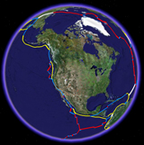
Why are there earthquakes in the Bay Area? The Bay Area lies on an active plate boundary, one that separates the North American and Pacific plates. As the two plates grind past each other at a rate of about 2 in/yr (5 cm/yr), numerous earthquakes of all sizes occur along the boundary. As the Pacific plate moves north relative to the North American plate, strain is placed on the Bay Area faults. The 1868 earthquake was a result of build up of strain along the Hayward Fault. The plates keep moving, as they have for 30 million years, which means strain continues to build and future earthquakes like the 1868 are a certainty. Explore the tectonic plates of the world and the earthquakes that accompany them.
-
Earthquake Setting of the San Francisco Bay Area
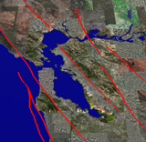
How close to an earthquake fault do you live? How do scientists know where the faults are? There are eight major faults in the Bay Area that take up the movement between the Pacific and North American plates. Explore the earthquake faults, geology, and seismic history in the Bay Area. Learn about some of the new methods that scientists are using to study the Bay Area faults.
-
The Hayward Fault and 1868 Earthquake
On October 21, 1868, at 7:53 AM, the Hayward Fault broke in the original “Great San Francisco Earthquake”. At the time, there were no seismometers, so the location of the epicenter is unknown, but there were observations that the Hayward Fault ruptured the surface from Fremont to Oakland, and perhaps as far north as Berkeley. From the initial shock at 7:53 AM up until 4:00 PM, 26 aftershocks rattled the Bay Area. The intense shaking caused much damage in the sparsely populated Bay Area. Learn more about the 1868 Hayward earthquake through photographs and accounts of the earthquake, and learn how scientists have used this information to determine the intensity of the earthquake.
-
Urbanization of the Hayward Fault
What does a fault look like? The Hayward Fault runs through, or near to, one of the most densely urbanized areas in North America. If you know what to look for, it is easy to spot the cracks where the fault cuts through roads, sidewalks, and even large structures like the University of Berkeley football stadium. Given its urban location, the Hayward Fault has probably been studied more than any fault in the world. Explore some of the data from recent studies along the Hayward Fault including photographs of recent movement along the fault.
-
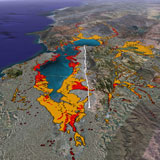
Earthquake Hazards of the Bay Area Today
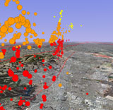
The San Francisco Bay Area has grown tremendously since 1868. More than 7 million people are now dependent on a complex and aging infrastructure that is vulnerable to the effects of future earthquakes in the region. See maps showing the earthquake probabilities and liquefaction susceptibility of the Bay Area.