

M 6.5 - 43 km S of Intipucá, El Salvador
- 2023-07-19 00:22:07 (UTC)
- 12.800°N 88.080°W
- 70.8 km depth
Interactive Map Regional Information Felt Report - Tell Us! 000200Responses Contribute to citizen science. Please tell us about your experience.
- Did You Feel It?
VIIImmi 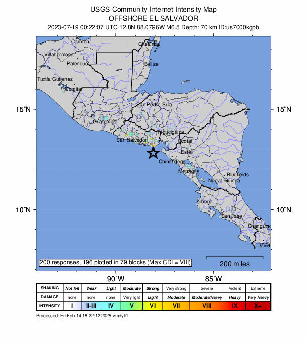
Community Internet Intensity Map - ShakeMap
VImmi 
Estimated Intensity Map - PAGER
YELLOW 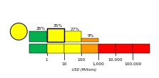
Estimated Economic Losses 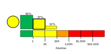
Estimated Fatalities Ground Failure - Landslide Estimate
Little or no area affected
Little or no population exposed
- Liquefaction Estimate
Limited area affected
Limited population exposed
Origin - Review Status
- REVIEWED
- Magnitude
- 6.5 mww
- Depth
- 70.8 km
- Time
- 2023-07-19 00:22:07 UTC
Moment Tensor Fault Plane Solution View Nearby Seismicity - Time Range

± Three Weeks - Search Radius

250.0 km - Magnitude Range

≥ 3.0
Contributors US

USGS National Earthquake Information Center, PDE