Surface Features-Faults
14 matching links found
- California Subduction Rocks — A photographic field trip to classic subduction-related rocks across northern California. (About Geology)
- Creep Evidence of Active Faulting — Information about creep on faults, and specifically the Hayward fault. (USGS)
- Earthquakes 101 "Slideshow" (PDF) — PDF format of a complete PowerPoint show for the basics (USGS)
- Education Resources — Education resources using geodetic data, GPS and visualization tools. (UNAVCO)
- GEODE - Google Earth for Onsite and Distance Education — Virtual tours of different earth features using Google Earth. (geode.net)
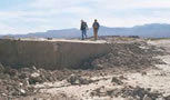
- Geologic Cracks Record Earthquakes on the Reelfoot Fault in Central U.S. — New high-resolution lidar data reveals cracks produced from strong shaking in past earthquakes in the New Madrid seismic zone. (USGS)
- Hayward Fault Field Guide — Interactive story map with 62 field trip stops for exploring the Hayward Fault in the East San Francisco Bay Area of California. (USGS)
- Intermountain West, U.S., 2020 Earthquakes — An interactive geonarrative (Esri story map) about the four Intermountain West earthquakes. Learn more about these quakes and the historic earthquakes in this part of the western U.S. This immersive experience (best viewed on a computer) includes maps, photos from the field and links to journal papers, earthquake event pages, data and more. (USGS)
- IRIS Education and Public Outreach — An amazing collection of excellent education resources for all aspects of earthquakes and seismology with great images! (IRIS - Incorporated Research Institutes for Seismology)
- New Madrid Seismic Zone — A collection of information about the region, the historical seismicity, and the hazards. (USGS)
- SCEC Communication, Education and Outreach — Many excellent resources for Public Education and Preparedness, K-14 Earthquake Education, and Experiential Learning and Career Advancement. Putting Down Roots in Earthquake Country downloadable booklets for learning about earthquake hazards and safety recommendations in many different languages and for many different areas of the United States. (Southern California Earthquake Center (SCEC))
- Schoolyard Geology — Online lesson plans with photos and images. Excellent geologic activities you can do anywhere! Education standards info included. (USGS)
- Seismicity of the Earth 1900?2018 Map/Poster — Poster-sized map illustrating 119 years of global seismicity in the context of global plate tectonics and the Earth?s physiography. Primarily designed for use by earth scientists, engineers, and educators, this map provides a comprehensive overview of strong (magnitude [M] 5.5 and larger) earthquakes since 1900. (USGS)
- Understanding Quakes — description, photos, and graphics of earthquake basics and effects of earthquakes in Turkey (The Why Files)