-
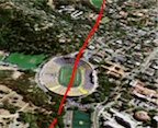
Virtual Tour using Google Earth
To start the tour, download and open the “Hayward Fault Map and Tour” file in Google Earth (free download), then click the “Play Tour” button located at the bottom of the “Places” panel. Bundled with the map and tour are: 1) photographs showing evidence of creep and other aspects of faulting, 2) locations of creep, 3) locations of exploratory trenches crossing the fault, 4) moving landslides (from InSAR, only available for northern Berkeley Hills), and the kilometer grid used in the published map.
This map is informational only and is not a regulatory map. Official state Earthquake Fault Zone maps that govern construction setbacks and disclosure are produced by the California Geological Survey. -
Maps and Database
- Page-sized map (pdf)
- Poster (24" x 36" pdf) of the map
- Download GIS data
- Interactive Maps
(Symbols and abbreviations)
-
See Also
- Accompanying pamphlet includes full report, references, and map abbreviations
- Official USGS publication for this report